Operate your entire operation from the extraction face to dispatch
An extractive or industrial operation is much more than the working face: it's the quarry, the material stockpiles, the conveyor belts and crushing, the substation and the line that reaches it, the settling pond and the water treatment plant, the truck loading, the workshops, the parking lots and the personnel areas. InfraOpera operates it all on a live map —the space and its geozones— ready for the environmental, mining and industrial-safety authority.
The operation is managed at risk and blind
An extractive or industrial operation handles high-risk assets —extraction faces, stockpiles, belts, kilns, ponds, loading lines— in a dynamic environment, with personnel and heavy vehicles moving between zones, and under environmental and industrial-safety demands. It's often managed with scattered information that turns into a safety risk and an authority finding:
The inventory lives in the team's memory
What infrastructure there is, where each monitored slope is, when it was intervened and with what result: that knowledge exists, scattered. With technical staff turnover, the critical data is lost.
Unverifiable monitoring
The report says the slope was inspected, but without geolocated, dated evidence, before the authority or after an event, that doesn't defend the operation or the people.
Operation with no control in a changing environment
The mine's geometry changes every day. Without a live map, chasing the real status of roads, slopes and faces through loose reports is a safety risk, not just a cost.
Risk before the environmental and mining authority
When the authority audits compliance with the mining plan and the environmental management plan, gathering the scattered evidence takes weeks and leaves gaps that compromise the title and the permit.
InfraOpera turns the mining operation into an operating system
Each mine asset with geometry, attributes and status. Each inspection with location, evidence and person responsible. Each decision with measurable backing before the authority.
Georeferenced mining inventory
Each mine-road segment, monitored slope, dump, pile and piece of infrastructure located on the map with its technical and control attributes.
Monitoring with evidence
Personnel or the drone inspect slopes, roads and faces, recording findings with a geolocated photo and status. Everything is tied to the asset and to a date that can't be altered.
Traceable maintenance and intervention
Each order is born from a finding or an exceeded threshold, is assigned, executed and closed with evidence. The complete history lives in the asset, ready for the authority.
Drone capture and mine progress
Engineering-grade orthomosaics and 3D models of the operation. A baseline of slopes and dumps, documenting progress and geometry changes flight by flight.
Every asset in the operation
From the extraction face to the loading line. The whole operation —extraction, process, services and environmental— inventoried, located and with its history.
Extraction face
Quarry, slopes, benches, dumps — geometry and stability
Stockpiles and crushing
Material piles (limestone, coal, scrap, pozzolan, ash), hoppers, crushers, conveyor belts
Plant and process
Kilns, mills, silos, workshops, offices
Loading and dispatch
Truck loading lines, scales, maneuvering yards
Power and services
Substation, incoming transmission line, fuel, communications
Environmental and water
Settling pond, treatment plant, channels, monitoring
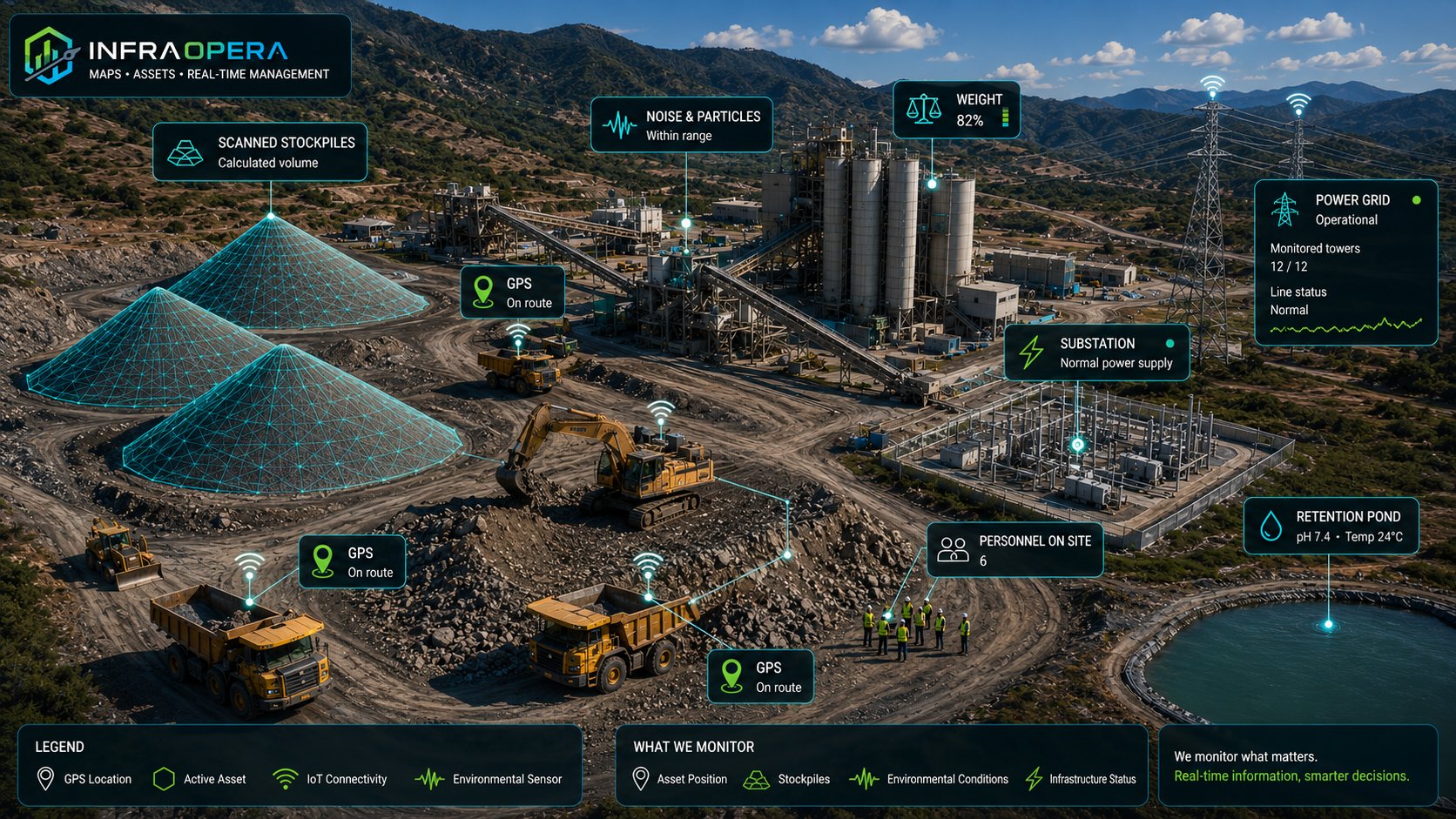
You don't just map the space: you define how it's interacted with
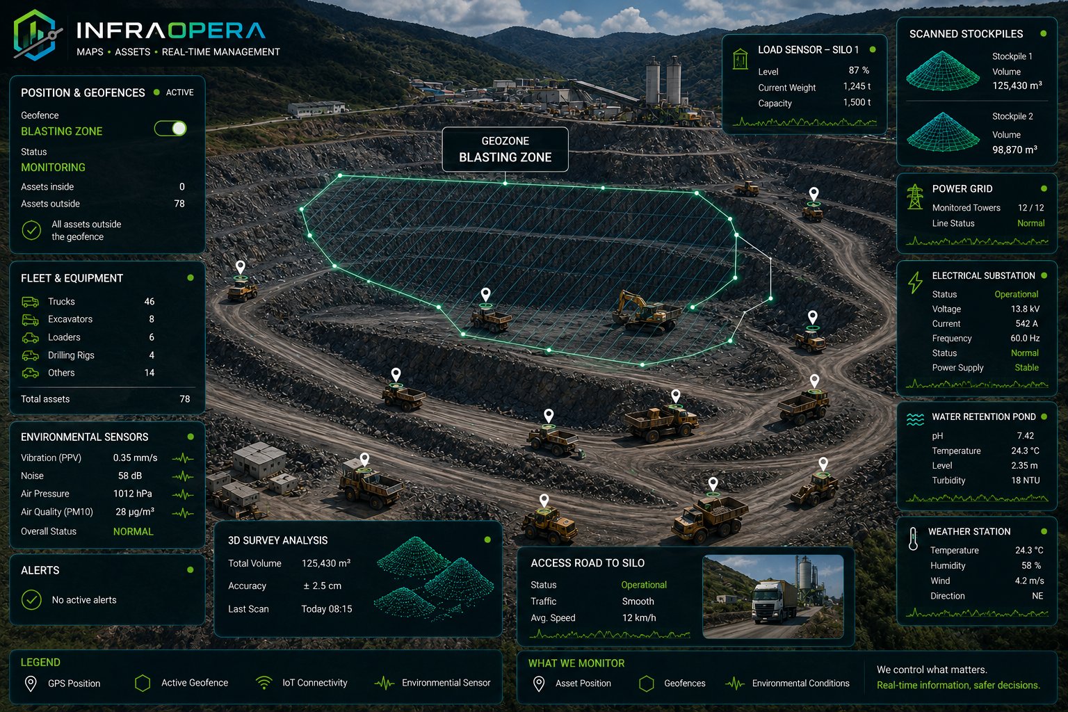
In an industrial operation, people, heavy vehicles, workshops and hazardous zones coexist on the same terrain. InfraOpera doesn't just map each asset: it delimits geozones and records how personnel and equipment interact with them, in real time.
Zones and their access control
Each zone —the extraction face, crushing, the stockpiles, the workshops, the loading area— is a geozone with its rules. When a vehicle or a person enters or exits, the system records it: who, where and when, without anyone writing it down.
Segregation of people and machinery
The greatest risk in these environments is the pedestrian–heavy-machinery interaction. If a person enters an equipment-operation geozone, or a vehicle a restricted zone, the alert is triggered according to the rule you defined.
Logistics traceability
Follow the operation's real flow: the truck that enters loading, passes the scale and leaves; the equipment that moves between the face and the workshop. Every movement stays on the map, to optimize times and back the operation.
Privacy and purpose: tracking is used for operational safety and traceability within the project's geozones. The policies of what is recorded and for how long are configured per project, under the client's legal and labor framework.
From finding to closeout, with evidence
A simple, traceable operating cycle, designed for a high-risk environment with environmental demands.
Load the operation
You upload the infrastructure, roads and slopes, or capture them with a drone. The entire mine becomes live on the map.
Monitor and report
Personnel or a sensor reports a finding from the map with exact location and photo. The incident is tied to the asset.
Assign with geofence
The work order is assigned to the team. On arrival at the zone, the geofence registers them. They execute and upload evidence.
Validate and archive
The supervisor approves with the evidence. The history stays in the asset, ready for the environmental and mining authority.
An operation that cares for those who work in it.
Personnel in a high-risk environment stop depending on the radio. A direct channel allows reporting a risk in a slope or a structure, a hazard on a road or a conveyor belt, a leak in the pond, an incident or an unsafe condition. Each report reaches the control center with exact location, in real time, and triggers the response the operation has defined.
Each report reaches whoever must respond
Living Mine is configured according to your operation's structure. You define the rule; the system routes each report to the right destination, with exact location and in real time:
- ⛰️ Slope risk Immediate alert to the geotechnical area and the control center for assessment.
- 🚧 Hazard on a road or process Notifies the mine-operations area responsible for that sector.
- 🚑 Incident or emergency Alerts the emergency brigade, with precise location within the operation.
The system routes and documents. Verification and the response decision remain in your operation's hands — InfraOpera executes the rule you defined.
Risk in a slope
Personnel report a crack, a material fall or an anomalous condition from the site. Geotechnical and the control center receive the exact location and act. People's safety doesn't wait.
Hazard on a mine road
A spill, a dangerous pothole, low visibility: anyone who sees it reports it. The operation steps in before an incident with heavy equipment.
Incident or emergency
An alert activates the emergency brigade with a precise location within the operation. The response is coordinated and recorded for the investigation.
Unsafe condition
Personnel walking the operation report what they see: an unsafe condition, a failure, an environmental risk. The whole operation looking after safety and the permit.
Every sensor, a defensible decision.
You decide what to measure and how you want to operate your mine. InfraOpera doesn't sell the hardware: it connects it. We identify in the market the open sensors your operation needs —slope radars and inclinometers, piezometers, vibration, air- and water-quality stations, level sensors— and integrate them into the same map where your assets live, with the solution designed to fit your requirement.
Support before the environmental authority
Air-quality stations, noise and particulate monitoring, and the pH and temperature sensors of the retention pond record and seal the environmental measurements, with dates. That history becomes the support to back compliance with the management plan before the environmental authority: traceable evidence, not estimates.
Safety and closeness to personnel
A sensor crosses the threshold you configured, or a piece of equipment enters a risk zone. InfraOpera generates the incident, creates an automatic geozone around the sector and triggers the response: it notifies the personnel and equipment inside, in real time, for an immediate evacuation — before an incident that costs lives occurs.
Automatic operation
A weight sensor warns that a silo is reaching its level; the noise and particulate monitoring at the crusher goes out of range; a level sensor controls the settling pond. Each reading can generate a traceable work order, with the support of AI —audible or by message— that suggests action scenarios for the operator to decide.
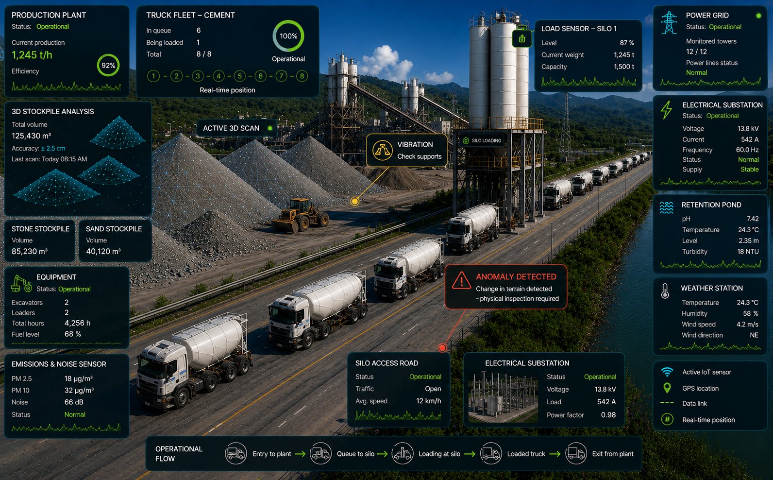
3D stockpile inventory
Material stockpiles are scanned in 3D and their volume is computed automatically with InfraOpera Capture. The stock inventory —stone, sand, inputs— stops being an estimate: it's a measured, dated and traceable figure, ready to reconcile production and dispatches.
What changes when you operate with InfraOpera
The backing of the mining operation and permit, in one place
A mining operation handles high-risk assets under environmental and safety demands. InfraOpera doesn't just give you operational control: it turns the operation into a secure digital record, indexed and instantly searchable. It's not just production — it's verifiable backing before the authority and protection of the license to operate.
The operation's memory, not people's
The technical knowledge of slopes and assets stops leaving with turnover. It stays in the organization, backed up and available.
Ready for the authority
Each monitoring and intervention with its evidence, date and person responsible. What the environmental and mining authority asks for in weeks, you deliver documented.
Backing for the social and legal license
The real status of the operation, supported and auditable. Backing that sustains compliance, protects the license and defends against events.
Your mining operation, under control
We set up the initial inventory, the operational map and a real case running. No vague promises: operational control from the first month.