Operate your network point to point, span by span
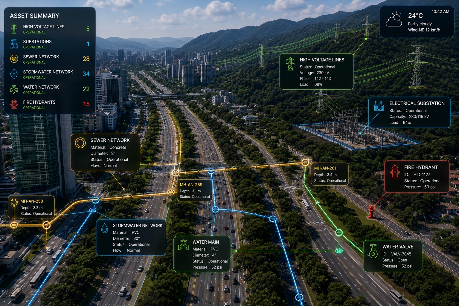
All the infrastructure that carries a resource from one place to another —power, telecom, water, gas— overhead or buried, on a live map. Lines and towers, repeaters, substations, generation and pumping centers, and buried networks recorded as designed and as built. Each asset with its geometry, its attributes and its field evidence —even in remote areas— ready for the operator and the regulator.
The network is operated across hundreds of miles, blind
A transmission network —electric, telecom, water or gas— stretches across miles of terrain, with visible overhead spans and buried sections no one sees, thousands of critical assets, and is often managed with scattered information that turns into failure risk, downtime and regulatory penalties:
The inventory lives in the team's memory
How many towers, repeaters, substation equipment or buried pipe segments there are, where they are, what diameter and material they have and in what condition: that knowledge exists, scattered across drawings and heads. With turnover, the critical data of a remote asset —or of a network you can't see— is lost.
Unverifiable inspections
A line inspection reports the condition of a tower, but without geolocated, dated evidence, before the regulator or during a failure, that doesn't defend the operation.
Crews with no control in remote terrain
Did the crew reach the right tower among hundreds? What did they do? In hard-to-access easements, chasing evidence without traceability multiplies costs and safety risks.
Regulatory risk from downtime
When the regulator audits the network's availability and maintenance, gathering the scattered evidence takes weeks and leaves gaps that cost in compensations and penalties.
InfraOpera turns the network into an operating system
Each network asset with geometry, attributes and status. Each inspection with location, evidence and person responsible. Each decision with measurable backing before the network operator.
Georeferenced network inventory
Each tower, span, insulator, substation and piece of equipment located on the map with its technical, contractual and warranty attributes, along the entire route.
Inspection with evidence
The crew or the drone inspects the line, recording findings with a geolocated photo and status. Everything is tied to the asset and to a date that can't be altered.
Traceable maintenance
Each work order is born from a finding, is assigned, executed and closed with evidence. The complete history lives in the asset, ready for the regulator.
Drone line inspection
Engineering-grade aerial capture of the route. A baseline of towers and spans, documenting deterioration, vegetation in the easement and evolution flight by flight.
Every asset in the network
From the high-voltage tower to the buried pipe. All transport infrastructure —overhead and underground— inventoried, located and with its history.
Lines and overhead structures
Towers, poles, spans, cables, splices, fittings
Substations and nodes
Transformers, breakers, busbars
Generation and pumping
Plants, pumping stations, critical equipment
Telecom and repeaters
Signal repeaters, TV and internet networks, communications
Buried networks
Pipe, manholes and inspection chambers, valves, pressure breaks — with diameter, material and as-built
Easements and corridors
Vegetation, access roads, encroachments
The buried network isn't a pipe: it's infrastructure with attributes
What's underground is the hardest to operate, precisely because you can't see it. InfraOpera records your buried networks as designed and as built (as-built), and puts them on the map with all their engineering detail.
Each segment, with its data sheet
It's not just a line on the map. Each segment holds its diameter, material, pipe type, supplier and installer, its construction date and its warranty. You tap the segment and know what you're working with before you break the street.
All the infrastructure along the route
A buried network is much more than pipe: manholes and inspection chambers, valves, pressure breaks, fittings. All georeferenced and tied to their history, not lost in a drawing no one can find anymore.
Design versus as-built
We record how it was designed and how it was built. That difference —the one usually lost— is documented, so the next intervention starts from reality and not from an outdated drawing.
Why it matters: when there's a leak or a failure, you don't improvise. You know which segment it is, what material, what diameter and which valve to close — and you order the right supply from the start, while the crew is already on its way to the exact spot.
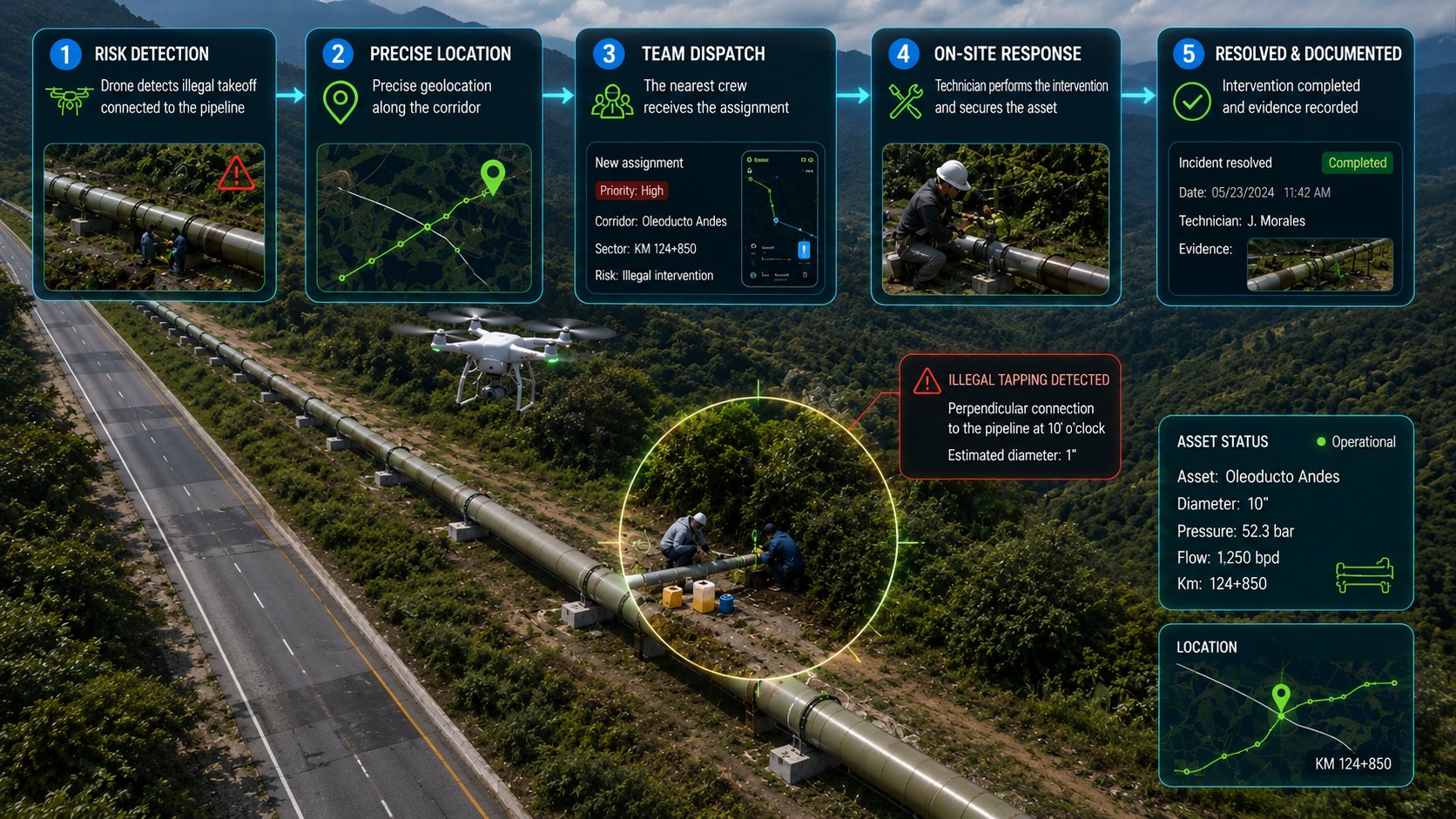
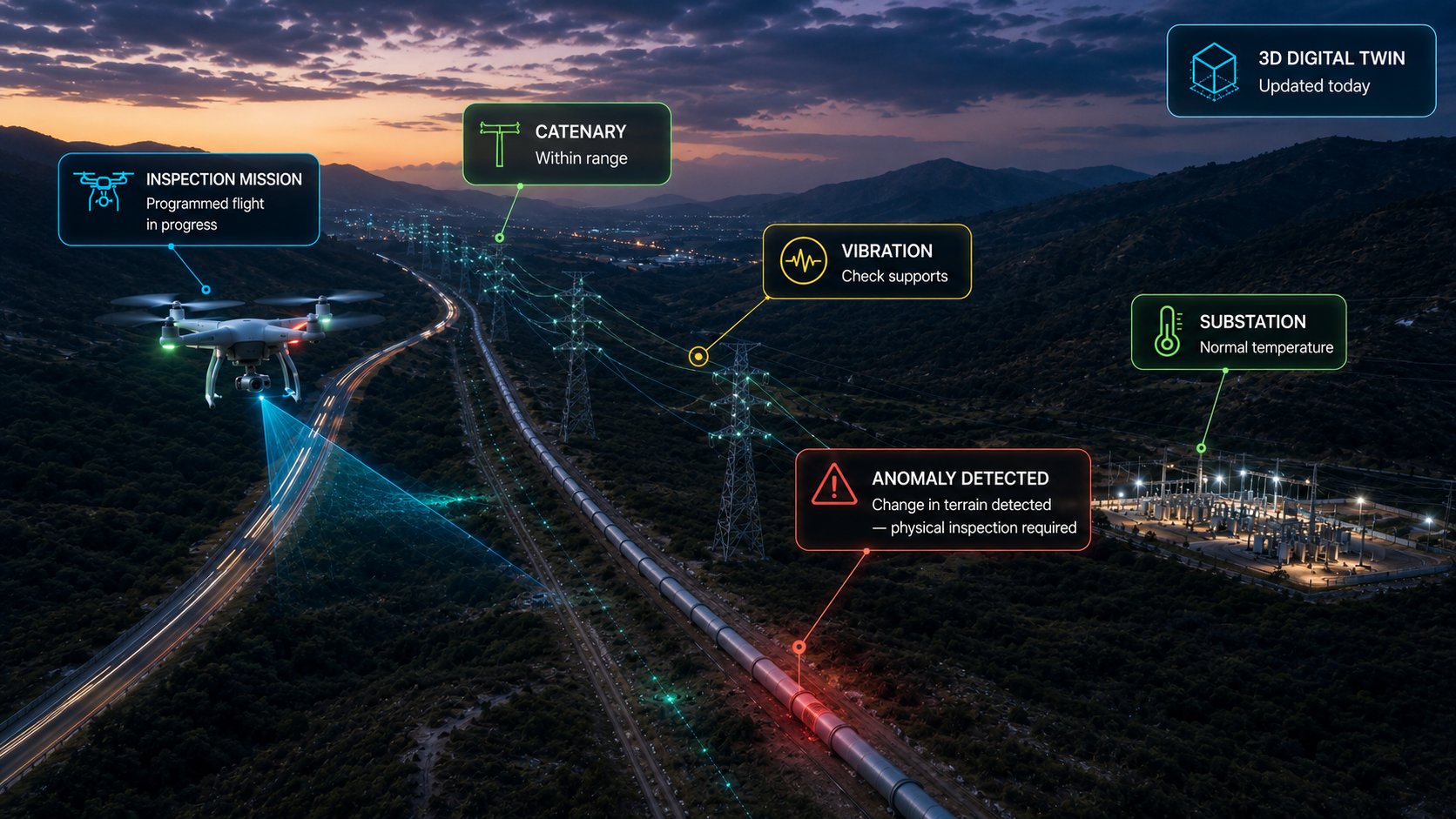
Inspect the whole network without driving all of it
A network stretches across hundreds of miles. Driving it entirely with crews is slow, expensive and exposes personnel. InfraOpera flips the logic: first everything is viewed from the air, and the physical crew goes only where there's already an evidenced problem.
Scheduled mission
You schedule recurring inspection flights. InfraOpera plans the mission; the market's autonomous drone executes it. We don't operate the drone — we integrate with it.
Digital twin
With what's captured, InfraOpera Capture produces the corridor's digital twin: orthomosaic and engineering-grade 2D/3D model, with a verified date.
Anomaly detection
On that model, anomalies worth reviewing are detected: a catenary out of range, invasive vegetation, an unauthorized excavation or a change in the terrain over a duct.
You validate and report
Within InfraOpera you inspect, validate the condition and generate the report of the critical sites —with their exact location— that require physical intervention.
Crew to the exact spot
The physical inspection crew goes only to the marked points, not to every mile. It arrives at the right place, with the context already documented.
Optimize resources and protect your personnel. Instead of sending crews to drive the entire network, you direct them only to where there's already evidence of a problem. Fewer miles driven blind, less personnel exposure in remote or risky areas, and every intervention justified with data.
From finding to closeout, with evidence
A simple, traceable operating cycle, designed to manage a dispersed network with regulatory demands.
Load the network
You upload the route, towers and substations, or capture them with a drone. The entire network becomes live on the map.
Inspect and report
The crew or the drone reports a finding from the map with exact location and photo. The incident is tied to the asset.
Assign with geofence
The work order is assigned to the crew. On arrival at the tower —even a remote one— the geofence registers it. They execute and upload evidence.
Validate and archive
The supervisor approves with the evidence. The history stays in the asset, ready for the regulator.
A network that protects those who live beside it.
The crew in remote terrain and the community next to the corridor stop being out of touch. A direct channel allows reporting a damaged structure, a leak or an exposed section, dangerous vegetation, a blocked access or a risk in the network. Each report reaches the operations center with exact location, in real time, and triggers the response the operator has defined.
Each report reaches whoever must respond
Living Network is configured according to your operation's structure. You define the rule; the system routes each report to the right destination, with exact location on the route and in real time:
- ⚡ Risk in the network An electrical risk, a leak or a compromised section: immediate alert to the operations center for assessment and switching.
- 🌿 Vegetation in the easement Notifies the easement-management crew responsible for that section.
- 🚨 Emergency or risk to third parties Alerts the emergency service and the authority according to the rule you defined.
The system routes and documents. Verification and the response decision remain in your operation's hands — InfraOpera executes the rule you defined.
Electrical risk reported
The crew or a third party reports a downed conductor, a damaged insulator or a risk from the site. The operations center receives the exact location and acts. People's safety doesn't wait.
Dangerous vegetation
Anyone who sees vegetation growing toward the line can report it. The easement crew steps in before it causes a failure or a fire. Prevention before downtime.
Blocked access to a tower
The crew reports an obstructed access or an irregular occupation of the easement. It's georeferenced and tied to the asset, with support for land management.
Notice to the community
Scheduled work, outages, risks: the operator informs the community within the easement's geozone, in real time.
Every sensor, a defensible decision.
You decide what to measure and how you want to operate your network. InfraOpera doesn't sell the hardware: it connects it. We identify in the market the open sensors your operation needs —inclinometers, vibration, temperature, weather stations, corona sensors— and integrate them into the same map where your assets live, with the solution designed to fit your requirement.
Support before the regulator
Condition and availability sensors record and seal the status of the assets, with dates. That history becomes the support to back availability and maintenance before the regulator: traceable evidence that defends against compensations and penalties.
Safety and prevention
An inclinometer on a tower or a vibration sensor on substation equipment crosses the threshold you configured. InfraOpera generates the incident, creates an automatic geozone and triggers the response before the failure causes downtime.
Automatic operation
A temperature sensor warns of overload on a conductor; a weather station anticipates a storm over a section; an inclinometer detects the movement of a tower that could fall. Each reading can generate a traceable work order, with the support of AI —audible or by message— that suggests action scenarios for the operator to decide.
Closeness to the community
Telemetry doesn't just protect the network: it protects people. A risk detected on a section near homes can be notified to the community within the easement's geozone, in real time.
What changes when you operate with InfraOpera
The backing of the network's critical infrastructure, in one place
A transmission network is extremely high-value critical infrastructure under strict regulation. InfraOpera doesn't just give you operational control: it turns the network into a secure digital record, indexed and instantly searchable. It's not just operation — it's verifiable backing before the regulator and investors.
The network's memory, not people's
Knowledge of the remote asset stops leaving with turnover. It stays in the organization, backed up and available.
Ready for the regulator
Each inspection and maintenance with its evidence, date and person responsible. What the regulatory audit asks for in weeks, you deliver documented.
Transparency for investors
The real status of the network, supported and auditable. Backing that sustains investment decisions and protects the value of the regulated asset.
Your transmission network, under control
We set up the initial inventory, the operational map and a real case running. No vague promises: operational control from the first month.