Operate your road corridor mile by mile
Inventory, inspection and maintenance of roads, bridges, signage and drainage on a live map. Each asset with its status, its history and its field evidence — ready for audits by the regulator or the Grantor.
The road is operated blind
Road infrastructure is among the most expensive to maintain, and yet it's operated with scattered information, no traceability and late reactions. This is what costs money and exposes you in audits:
The inventory lives in the team's memory
What was built, who installed it, when and under what warranty: that knowledge exists, but split across drawings, contracts, accounting and each engineer's head. When that person isn't there, neither is the data.
Unverifiable inspections
A report says a pothole was repaired, but there's no geolocated evidence or reliable date. In a contractual dispute, that defends no one.
Operation with no field control
Did the contractor arrive? What are they doing? How long did it take? Are they where they say they are? Collecting evidence site by site over WhatsApp/SMS/email turns you into a messaging switchboard with no traceability — and every hour without control is cost.
Risk in audits
When the Grantor or the supervisory body asks for an account, gathering the scattered evidence takes weeks and leaves gaps that cost money.
InfraOpera turns the road into an operating system
Each corridor asset with geometry, attributes and status. Each task with location, evidence and person responsible. Each decision with measurable backing.
Georeferenced road inventory
Each post, sign, culvert, joint and stretch of pavement located on the map with its technical, contractual and warranty attributes.
Inspection with evidence
The inspector drives the road, recording faults with a geolocated photo and status. Everything is tied to the asset and to a date that can't be altered.
Traceable maintenance
Each work order is born from a detected fault, is assigned, executed and closed with evidence. The complete history lives in the asset.
Validated drone capture
Engineering-grade orthomosaics and models of the corridor. Capture a baseline of the road and document its evolution flight by flight: construction progress, deterioration, interventions.
Every asset in the corridor
From the pavement to the last road stud. All inventoried, located and with its maintenance history.
Pavement
Sections, potholes, cracks, rutting
Bridges and viaducts
Structures, joints, bearings
Signage
Vertical, horizontal, traffic lights
Drainage
Culverts, ditches, box culverts
Lighting
Poles, fixtures, networks
Road safety
Barriers, guardrails, road studs
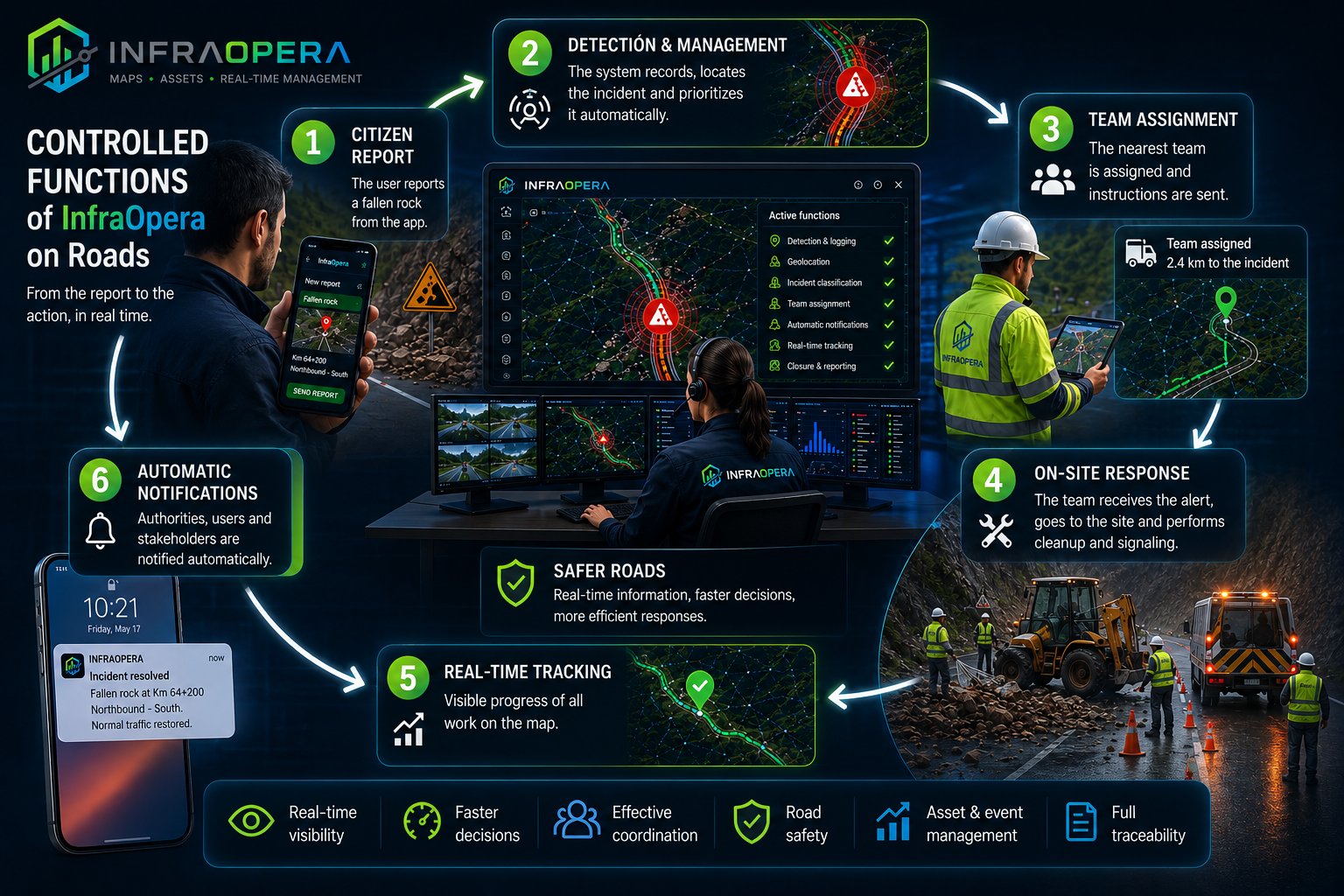
From fault to closeout, with evidence
A simple, traceable operating cycle, designed so nothing gets lost and everything is documented.
Load the corridor
You upload the alignment and existing assets, or capture them with a drone. The road becomes live on the map.
Detect and report
The inspector or operator reports a fault from the map with exact location and photo. The incident is recorded and tied to the asset.
Assign and execute
The work order is assigned to the contractor. On arrival, the geofence registers them. They execute and upload evidence.
Validate and archive
The supervisor approves with the evidence. The history stays in the asset, ready for any audit.
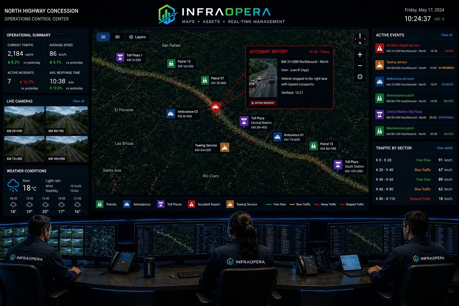
A road that cares for those who travel it.
The driver is no longer alone. From the moment they enter your concession, they have a direct channel to ask for help, report a risk or flag what they see. Each interaction reaches the operations center with exact location, in real time, and triggers the response your operation has defined.
Each alert reaches whoever must respond
Living Road is configured according to your infrastructure and your responsibility on the ground. You define the rule; the system routes each report to the right destination, with exact location and in real time:
- 🚨 Accident on the road Alerts the nearest emergency service; once the severity is verified, the response is escalated.
- ⚠️ Rockfall Notifies the maintenance team responsible for that sector.
- 🛡️ Security alert Reaches the nearest police station.
The system routes and documents. Severity verification and the response decision remain in your operation's hands — InfraOpera executes the rule you defined.
Breakdown on the road
The driver reports from the site. The concession dispatches a tow truck or mobile workshop to the exact spot. No missed calls, no imprecise coordinates, no dead time hunting for where the vehicle is.
Dangerous situation
A driver's alert simultaneously activates the concession's operations center and the police. The location is precise. The response is coordinated. The driver knows someone is on the way.
Hazard on the road
Rockfall, landslide, accident, obstacle: any driver who sees it can report it. The concession steps in before the problem escalates. Thousands of eyes on the road, with no added patrol cost.
Wildlife sighting
Each report is georeferenced and dated. Direct support for the environmental monitoring required by the permit, prevention of roadkill and traceability before the environmental authority.
Every sensor, a defensible decision.
You decide what to measure and how you want to interact with your corridor. InfraOpera doesn't sell the hardware: it connects it. We identify in the market the open sensors your operation needs —accelerometers, inclinometers, pyranometers, rain gauges, level sensors, traffic counters— and integrate them into the same map where your asset lives, with the solution designed to fit your requirement.
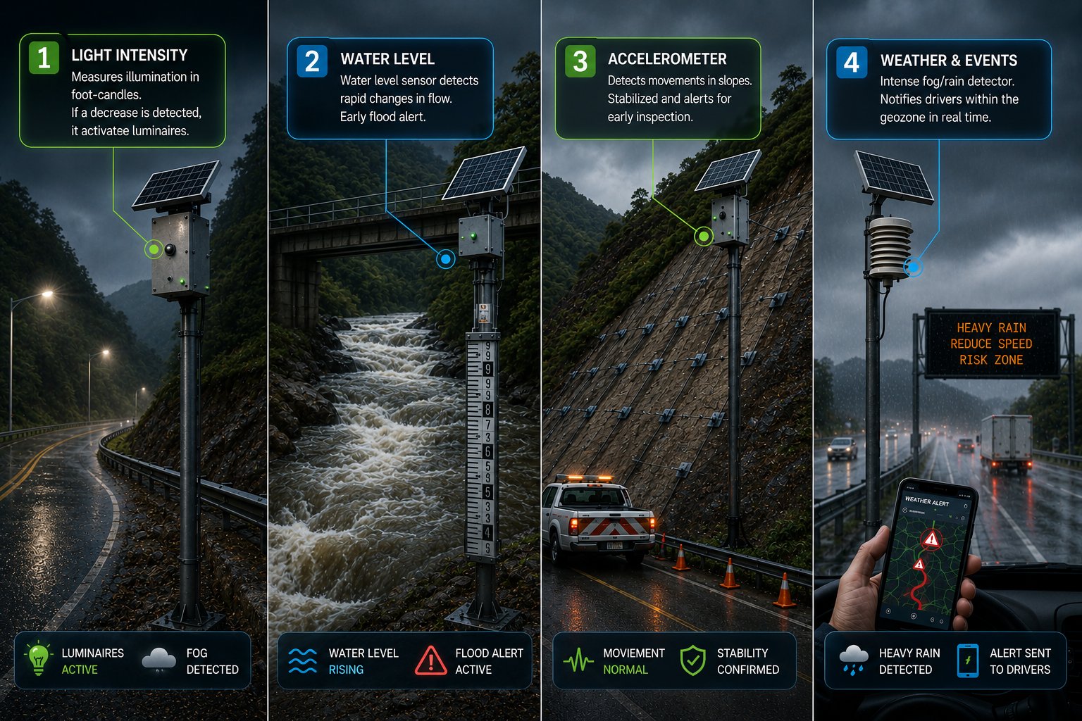
Contractual support
A rain gauge and a moisture sensor at the work front record and seal each event, with date and location. That history becomes the support to back a request for a time extension before the supervisory body: traceable evidence of the non-working days, ready for your contractual claim.
Safety and prevention
An accelerometer or inclinometer on a critical slope crosses the threshold you configured. InfraOpera generates the incident, creates an automatic geozone around the point and triggers the response: alert to the operations center and a work order, before the risk escalates.
Automatic operation
A level sensor on a bridge over a major waterway can be the early warning that saves lives; a light sensor switches on a sector's lighting when visibility drops due to fog or rain, even in daytime; the count at each toll booth records how many vehicles pass and also serves as a traffic count. Each reading can generate a traceable work order, with no manual intervention and with the support of AI —audible or by message— that suggests possible action scenarios for the operator to decide.
Closeness to the road user
Telemetry doesn't just protect: it accompanies. A reading of fog, intense rain or an event in a sector can notify the drivers who are inside the geozone created by the report. The road stops just signaling — it informs in real time those who travel it.
What changes when you operate with InfraOpera
The backing of hundreds of millions in infrastructure, in one place
A road corridor is an extremely high-value asset. InfraOpera doesn't just give you operational control: it turns that asset into a secure digital record, indexed and instantly searchable. It's not just value for your investment — it's verifiable backing of it.
The company's memory, not people's
Knowledge of the asset stops living in heads and loose files. It stays in the organization, backed up and available even if the team changes.
Ready for the supervisory body
Each intervention with its evidence, date and person responsible. What the supervisory body or the Grantor asks for in weeks, you deliver in minutes.
Transparency for investors
The real status of the asset, supported and auditable. Backing that sustains investment decisions and protects the value of the committed capital.
Your road corridor, under control
We set up the initial inventory, the operational map and a real case running. No vague promises: operational control from the first month.