Operate public spaces park by park
Inventory, maintenance and operation of the city's parks, plazas and public spaces —playgrounds, lighting, furniture, irrigation, fountains— on a live map. Each asset with its status, its history and its evidence, ready for public accountability.
Public space is operated blind
Parks and plazas are the shared asset of every citizen, and they're operated with scattered information, no traceability and reacting to complaints. This is what costs public budget and exposes you under citizen oversight:
The inventory lives in the team's memory
How many playgrounds, benches, light fixtures and fountains there are, where they are and in what condition: that knowledge exists, scattered. With every change of municipal administration, the data is lost.
Unverifiable maintenance
The report says the park's playground was repaired, but there's no geolocated evidence or reliable date. Before an oversight body or the public, that defends no one.
Contractors with no control across the city
Did the crew show up at the right park? What did they do? How long did it take? Collecting evidence park by park is unfeasible — and every unsupported contract is an audit finding.
Public accountability
When an oversight body or the public asks for an account, gathering the scattered evidence takes weeks and leaves gaps that compromise the administration.
InfraOpera turns public space into an operating system
Each urban asset with geometry, attributes and status. Each task with location, evidence and person responsible. Every public dollar with measurable backing.
Georeferenced urban inventory
Each playground, bench, light fixture, fountain and stretch of path located on the map with its technical and maintenance attributes.
Maintenance with evidence
The crew records each intervention with a geolocated photo and status. Everything is tied to the asset and to a date that can't be altered.
Traceable citizen service
Each citizen report is born from an incident, is assigned, executed and closed with evidence. The complete history lives in the asset.
Drone baseline
Capture a baseline of each park. Document the status of public space for planning, insurance and comparison over time.
Every asset in public space
From the central fountain to the last bench. All inventoried, located and with its maintenance history.
Playgrounds
Structures, swings, surfaces
Lighting
Poles, fixtures, networks
Street furniture
Benches, tables, trash bins
Fountains and water
Fountains, reflecting pools, irrigation
Green areas
Lawns, tree cover, gardens
Sports areas
Courts, outdoor gyms
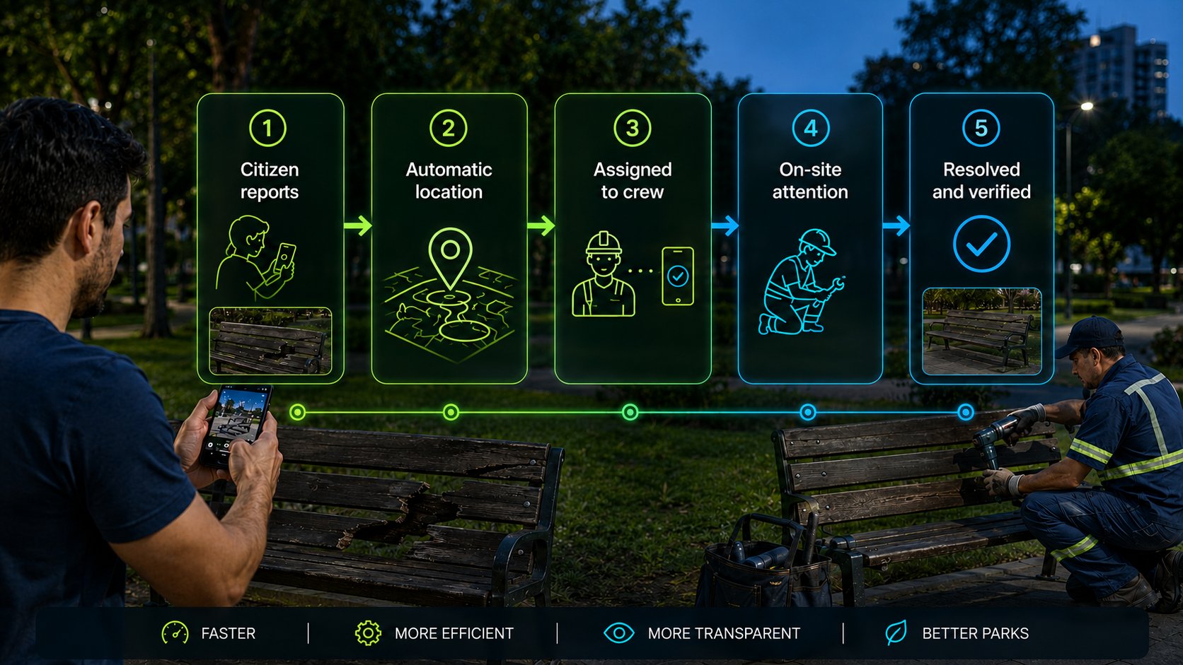
From report to closeout, with evidence
A simple, traceable operating cycle, designed to respond to the public and document the work.
Load the parks
You upload the spaces and assets, or capture them with a drone. Each park becomes live on the map.
Report or detect
The citizen, the inspector or a sensor reports an incident from the map with exact location and photo.
Assign and execute
The work order is assigned to the nearest crew. On arrival, the geofence registers it. They execute and upload evidence.
Validate and archive
The supervisor approves with the evidence. The history stays in the asset, ready for citizen oversight.
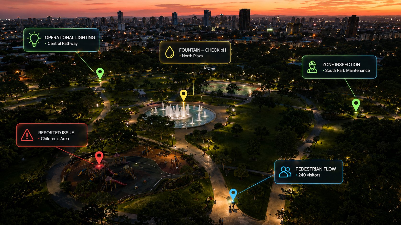
A public space that listens to its city.
The citizen stops shouting into the void. From their phone they have a direct channel to report a damaged playground, a light that's off, an accident or a risk. Each report reaches the operation with exact location, in real time, and triggers the response the administration has defined.
Each report reaches whoever must respond
Living City is configured according to your administration's structure. You define the rule; the system routes each report to the right destination, with exact location and in real time:
- 🔧 Damage in the park Notifies the maintenance crew responsible for that zone.
- 🚑 Accident or emergency Alerts the nearest emergency service, with precise location within the park.
- 🚨 Security situation Reaches the relevant authority according to the rule you defined.
The system routes and documents. Verification and the response decision remain in your operation's hands — InfraOpera executes the rule you defined.
Reported damage
The citizen reports from the site. The administration dispatches the crew to the exact spot. No paperwork, no vague descriptions, no waiting for the next round.
Accident in the play area
A citizen's alert activates the nearest emergency service with a precise location. The response is coordinated and recorded.
Thousands of eyes across the city
A light that's off, a leak, a fallen tree: any citizen who sees it can report it. The administration steps in before it escalates, with no added surveillance cost.
Communication to the public
Maintenance closures, events, alerts: the administration informs those near the park, in real time.
When citizens report, wildlife is protected
Public space isn't just infrastructure: it's habitat. Every neighbor out for a walk can report a species sighting. It's not just environmental control — it's counting, route validation and preservation, with real data instead of guesswork.
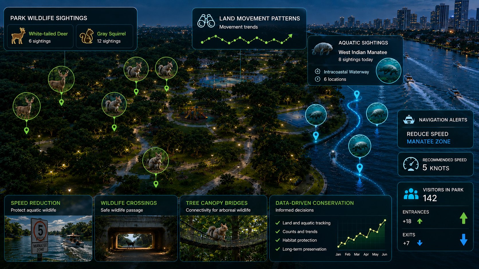
From sightings to routes
The same species reported at several points stops being an anecdote: it becomes a pattern. Repeated sightings —a deer here, a squirrel there, manatees along several stretches of the intracoastal— make it possible to reconstruct land and water routes and understand how wildlife moves.
Data that protects
With those routes, the administration can take informed measures: alert navigation to reduce speed in manatee zones, plan grade-separated wildlife crossings for safe passage, or build mesh bridges for tree-dwelling wildlife. The decision belongs to the administration; the data backs it.
Counting and trends over time
Each report is recorded with location and date. Over time you get counts, trends and traceability of the populations: a real basis for long-term conservation and for backing decisions before environmental bodies.
Every sensor, a defensible decision.
You decide what to measure and how you want to operate public space. InfraOpera doesn't sell the hardware: it connects it. We identify in the market the open sensors your operation needs —soil moisture, flow meters, water-quality, light, footfall counting— and integrate them into the same map where your assets live, with the solution designed to fit your requirement.
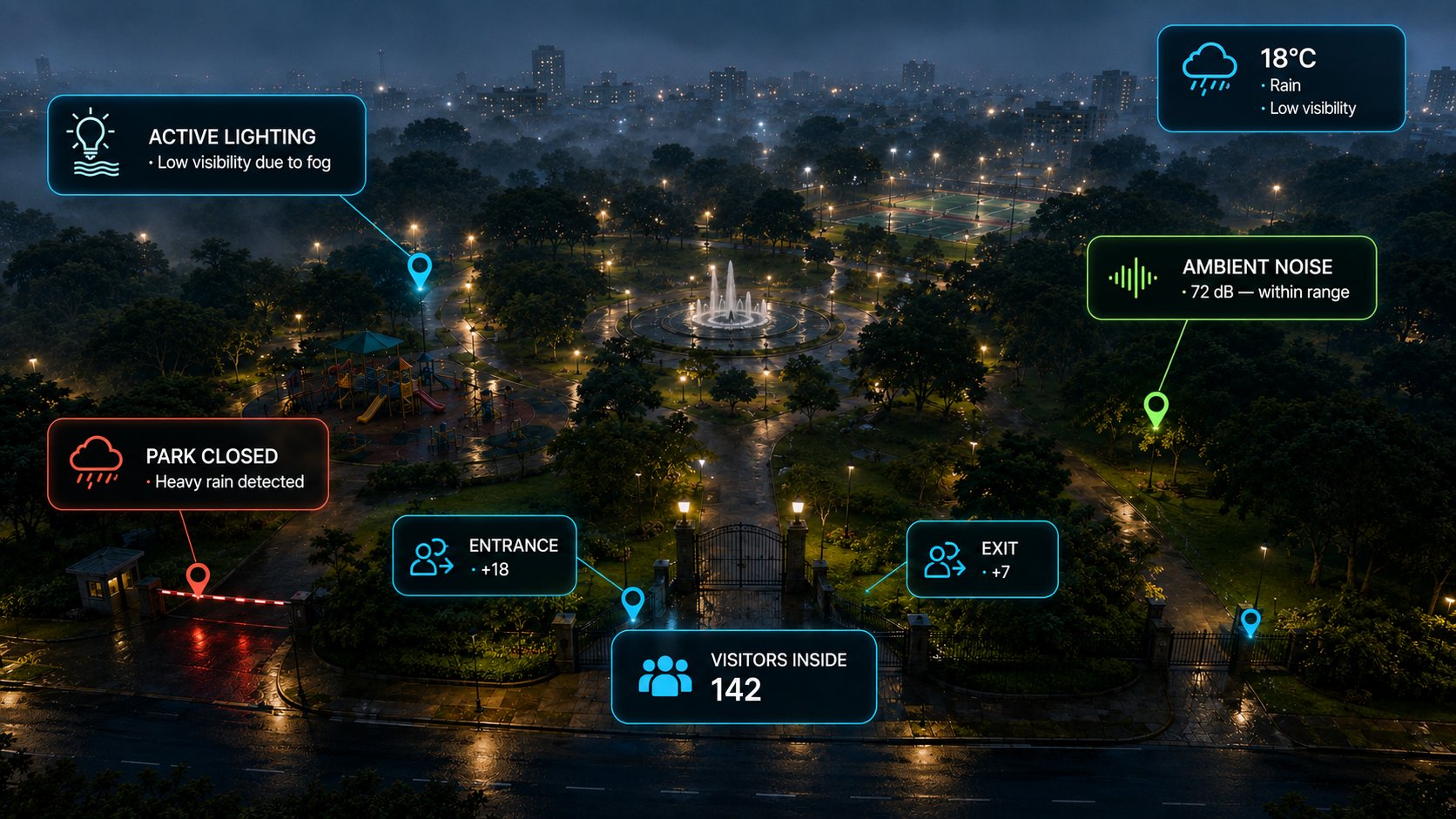
Support under oversight
Water and energy consumption meters record and seal each park's spend, with dates. That history becomes the support to back the budget and the execution before oversight bodies: traceable evidence, not estimates.
Security and capacity
Counting sensors at entrances and exits estimate how many visitors are inside the park at any moment. And if a motion sensor detects presence in an area after hours, InfraOpera generates the incident, creates an automatic geozone and triggers the response to the relevant authority.
Automatic operation
A soil-moisture sensor waters the park only when needed, saving public water; a quality sensor warns when a fountain's water goes out of range; in fog or cloud cover that reduces daytime visibility, lighting switches on by itself; and when it rains heavily, the system can trigger the park's closure according to the rule you defined. An ambient-noise sensor helps take corrective measures so the surroundings and wildlife keep suitable conditions. Each reading can generate a traceable work order, with the support of AI —audible or by message— that suggests action scenarios for the operator to decide.
Closeness to the citizen
Telemetry doesn't just operate: it accompanies. The closure of a zone, the maintenance of a fountain or a security alert can be notified to citizens within the park's geozone, in real time.
What changes when you operate with InfraOpera
The backing of the whole city's public patrimony, in one place
Public space is the patrimony of every citizen. InfraOpera doesn't just give you operational control: it turns that patrimony into a secure digital record, indexed and instantly searchable. It's not just management — it's verifiable backing of a transparent administration.
The city's memory, not the administration on shift
Knowledge of the public asset stops being lost with every change of government. It stays in the institution, backed up and available.
Ready for oversight
Each intervention with its evidence, date and person responsible. What an oversight body asks for in weeks, you deliver in minutes.
Transparency for the public
The real status of public space, supported and auditable. Backing that sustains public trust in the administration.
Your parks, under control
We set up the initial inventory of the public spaces, the operational map and a real case running. No vague promises: operational control from the first month.